|
|
 08-22-2010, 11:33 PM
|
#1 |
|
Mega-Contributor

Join Date: Sep 2007
Location: Where it doesn't snow...ever!
Posts: 21,926
|
Grand Canyon trip
My wife and one of her sisters cooked up a plan a few weeks ago to meet somewhere in southern Utah or northern Arizona and visit the Grand Canyon. We chose Kanab, Ut as the central location since it's only 74 miles from the North Rim. Last Thursday I rode there while my wife drove her car and we just returned home today. 981.4 miles round trip, according to my GPS.
Day 1 - Thursday, 19 August We left the house in Chandler around 08:00 AM and headed NE of the Phoenix area to Payson, then continued up AZ87 to Lake Mary Rd. It was 54 miles from the junction of Lake Mary Rd and AZ87 to Flagstaff. We went this way to avoid I-17 between Phoenix and Flagstaff. Lake Mary Rd is only 50 MPH, but it is much more scenic than I-17. We had lunch in Flagstaff and then took Hwy 89 north from Flagstaff to Bitter Springs, the route to the North Rim. After turning off 89 onto 89A, we were only about 20 miles from Lake Powell. The skies were overcast and I could see lightning over the lake. I soon hit a little drizzle but wasn't enough to warrant rain gear. Stopped for gas at Marble Canyon and had the privilege of spending $3.479 for 91 octane. Dark skies over Lake Powell:  Hwy 89A north from Marble Canyon parallels the Vermillion Cliffs. They are spectacular. Marble Canyon is where the Colorado River flows between Glen Canyon Dam (Lake Powell) and the Grand Canyon. The Vermillion Cliffs from Hwy 89A: 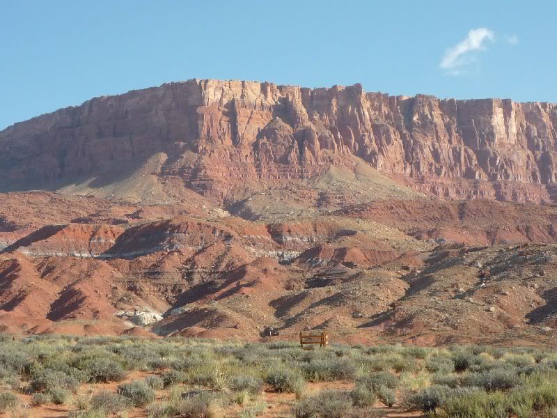 Marble Canyon (from Navajo Bridge, over 400+ above the water): 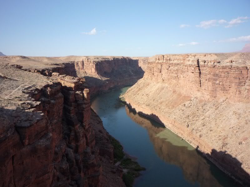 Past the Vermillion Cliffs, 89A starts climbing to the top of the Kaibab Plateau, which is where the North Rim is located. It started raining pretty good as I reached the base of the plateau and it got progressively worse as I gained elevation (up to 8000'). These storms are quite localized and usually don't last long, so I wasn't worried about rain gear. When we reached the Jacob Lake Inn, it started hailing, so on went the rain gear. From the Jacob Lake Inn, it's 40 miles to the Grand Canyon and 30 miles to Kanab, we turned right headed for Kanab. Less than 5 miles later, it was dry and sunny, so off went the rain gear. We arrived in Kanab around 5:30 PM and my wife's sister and her family were still a few hours away, so we enjoyed a dinner of Mexican food in Kanab. Day 2 - Friday, 20 August We (my wife and I in her car and her sister and family in their vehicle) set off for the Grand Canyon at about 10:30 AM. We headed back into AZ and Jacob Lake, then on to the North Rim. I had no idea Arizona could be so beautiful. Even though we've lived here since 1999, this was my first visit to the majestic hole in the ground. Approaching the National Park, we drove through tall stands of pine trees and green, lush meadows. Just inside the park, there was a herd of maybe 50 buffalo off the west side of the highway. We arrived at the North Rim Village and immediately started taking pictures. The Grand Canyon from the North Rim Village area:    We visited the North Rim Lodge, and here is a picture of the exterior of the dining room, which has a panoramic view of the canyon:  After spending a few hours and walking some trails, we decided to check out another vantage point. These next pics are from Point Imperial, which is NE of the North Rim Village. This is looking NE, beyond the canyon, the deep cut in the flat mesa is the Colorado River as it flows through Marble Canyon. The long stretch of bluffs in the far distance are the Vermillion Cliffs. The Lee's Ferry area of Lake Powell is just to the right of the cliffs.  The view to the SE:  On the way back to Kanab I came as close to hitting a deer (driving my wife's car) as I have in 35 years of driving. It was a young doe, and I stopped not more than a foot from it. My brother-in-law was driving the vehicle directly behind me and he said a larger doe, most likely its mother, was standing off near the tree line on our left. I didn't see her, I was more focused on Bambi. Day 3 - Saturday, 21 August My wife's family wanted to go horseback riding at Jacob Lake (they have 3 young kids), so I decided to take a ride in southern Utah. I rode from Kanab to Fredonia, AZ which is just across the border. Fredonia in on the AZ side, Kanab is on the UT side. I turned at Fredonia onto Hwy 389 and went through the famous polygamist enclaves of Colorado City AZ and Hildale UT, which straddle the border. About 20 miles up the road is Hurricane UT, the gateway to Zion National Park, having been to Zion several times, and because there is road construction through the tunnels, I decided to bypass the park this time. I went to St. George and had some lunch and then visited Zion Harley Davidson in Washington (UT) to buy some new sunglasses. I hopped on I-15 and drove about 45 miles north to Cedar City UT, then took Hwy 14 towards Brian Head ski resort. This route took me near Cedar Breaks National Monument. I didn't visit the monument, but took some pictures with part of the monument in the background:  This was at about 9800' above sea level. I'm embarrassed to admit I took this pic right after I dropped my bike. I pulled in to that pullout along the highway, which was on a steeper incline than I estimated. The bike went over very softly on its right side. The surface was gravel, and the bike was laying downhill, there was no way I could get it back up on my own. After a few minutes, and after being passed by a number of bikers, some guys in a Dodge truck stopped and helped me lift her back up. I pulled up to a more level area and took this picture and a couple others. Continuing further on 14, on the downhill side, I came upon Navajo Lake. The lake was formed millions of years ago when a now-extinct volcano spewed lava and it flowed into this valley and created a natural dam, backing up a creek and creating the lake. The lake has no visible outlet. The water seeps into some sinkholes and percolates through some fissures in the ground a few miles away. This area is covered for miles and miles with lava rocks. This was at about 8,000' and it is very scenic, as the pictures show:   Day 4 - Sunday, 22 August (no pics today, sorry) We left Kanab at about 07:00 AM local time and went through Page AZ rather than going back the way we came. We stopped for breakfast in Page and it was cloudy until we were about 120 miles from Phoenix. This kept the temperatures down and made the return trip very pleasant. The 100 miles from Payson to our home was hot, which was what one would expect this time of year. Sorry for the epic length, but I hope you enjoyed the pictures.
__________________
Scott "Cactusjack" Hanks VBA #00105 H.O.G. #4250060 2011 H-D Ultra Limited 103ci  :: 2011 HD Electra Glide Ultra Limited w/Stage 1 :: Rallies: Mesquite '08|Custer '09|Cortez '10|Crescent City '11|Kanab '12|Antlers '12|Estes Park '13|Antlers '13|Orofino '14|The Dalles '17 Login or Register to Remove Ads |

|
|
|
 Similar Threads
|
||||
| Thread | Thread Starter | Forum | Replies | Last Post |
| Hell's Canyon Rally | nomad561 | Rides/Trip Reports/Travel Information | 2 | 05-03-2011 10:00 PM |
| Hells Canyon | cyclecat | NorthWest Group | 21 | 06-22-2010 10:13 PM |
| Hells Canyon- Memorial Weekend | Netnorske | Rides/Trip Reports/Travel Information | 6 | 05-29-2009 11:44 PM |
| Road Trip through Titus Canyon, NV | Yellow Jacket | Off-Topic | 4 | 01-30-2009 12:55 PM |
| Canyon Ranch Run: the video. | Vulcan Nomad/Vaquero/Voyager | 19 | 08-20-2008 12:05 PM | |


 Threaded Mode