|
|
 11-24-2009, 08:32 PM
|
#31 |
|
Sr. Contributor

Join Date: Apr 2008
Location: Tamworth New Hampster 06 1600
Posts: 12,484
|
Satellite Photo Mystery?
Around here were have rock formations, but you see these closer. The "Old Man of the Mountains" is gone.. Fell off Cannon Mtn in a fog I think in 03. A memorial is being built or considered being built and a model if this is at the museum on site.
Another rock formation at about the same place and lesser known is the cannon, and can't be seen in foliage seasons. A few miles south is a likeness called Indian Head. East of there on Rt 302 is "Elephant Head" This is all remants of glaciers, and nothing a satilite would be able to see for proper viewing. Other attractions geolodgicly speaking are the Madison Bolder, probably the largest glacial erratic on land in the world, and several rivers carved by rocks into rocks making odd smooth bowls and cascades. I like things like this. For kicks if you like this is where i lived and do live now sort of. http://maps.google.com/maps?hl=en&tab=wl I used the zip code 03886. When the maps displays, to the south you will see the 'Ring Dike' I once lived dead center in. A said to be extinct volcano. You can drag the map and zoom in a little to see it better. Maybe try the 'terrain' mode. I really did live there 3.5 years dead center.. I am in Tamworth now, and that is easy to find the village. If you move the map to show what is North, sooner or later Mt Washington and the Presidential Range should come to view. For some reason a minor peak called Mt Clay appears when you are zoomed out a bit too much. Mt Washington is just a smigen south of that peak.
__________________
 06 1600 Nomad Just call me Mac molon labe come and get it Login or Register to Remove Ads |

|
|
11-24-2009, 08:48 PM
|
#32 |
|
Advanced Member

Join Date: May 2009
Location: Edmonton, Alberta, Canada
Posts: 822
|
Satellite Photo Mystery?
From Wikipedia, the free encyclopedia
The Badlands Guardian is a geomorphological feature located at 50°00′38.20″N 110°06′48.32″W / 50.010611°N 110.1134222°W / 50.010611; -110.1134222 near Medicine Hat in the south east corner of Alberta, Canada. Viewed from the air, the feature bears a strong resemblance to a human head wearing a full native American headdress. Because of additional man-made structure, it also appears to be wearing earphones.[1] The apparent earphones are a road and an oil well, which has been in place only a few years, and will likely become invisible once the well falls into disuse and its superficial features are eroded.[2] The head is a drainage feature created through erosion of soft, clay-rich soil by the action of wind and water.[1][3] The arid badlands are typified by infrequent but intense rain-showers, sparse vegetation and soft sediments. The 'head' may have been created during a short period of fast erosion immediately following intense rainfall. Although the image appears to be a positive feature, it is actually a negative feature (a valley).[4]
__________________
Psychocycle  VBA # 1125 2002 1500 fi Nomad 
|
|
|
|
11-24-2009, 09:06 PM
|
#33 |

Join Date: Jul 2008
Location: North Central Illinois
Posts: 8,575
|
Satellite Photo Mystery?
Mac:
I can see where they believe that area was a volcano. It likely was from what I can tell. Very interesting. Psychocycle; thanks for the update. Didn't realize this was a depression area.
__________________
 "During times of universal deceit, telling the truth becomes a revolutionary act." "You can have your own opinion, but not your own facts." Former VBA NCR Assist Regional Leader Formerly: 2004 1500FI Bronze Nomad: 2009 & 2014 HD Ultra Current Rides: 2017 HD Ultra Limited & 2011 Can Am Spyder RTS-SE Attended: VBA National Rallies 2009, 2011, 2015; VBA/NCR Regional Rally 2010, 12, 14, 16 and several rides throughout with regional members. VBA Member #652 HOG Member #3935417 |
|
|
|
11-25-2009, 10:12 AM
|
#34 |
|
Sr. Contributor
Join Date: Apr 2008
Location: Tamworth New Hampster 06 1600
Posts: 12,484
|
Satellite Photo Mystery?
glwilson, it was a real volcano once... It is said to have towered over Mt Everest and said to have been 41,000 to 47,000 feet.
There is stone from blown to the south west, showing it detonated violently in the ancient past, and then more recently was run over by ice 1 mile thick, twice. Once I had a copy of an Edison Report mentioning this and as the nothern terminus of a major east coast failt line presently over due to snap by around 250 years. The southern end so far as I know ends at Plum Island in Mass, near the NH-Mass border, but I suspect it ends in the Atlantic someplace south east of there. In the reprt the terms were of magnetic and non-magnetic plutons... The area is mineral rich, with gold ores, urainum ores used in WW-2 efforts, and took stones in a variety of type from modern sharpening stone similar to Arkansas stones, to Paleo used cherts. Amethest, quarts, topaz are sometines found by mineral collectors and other related stones as well like berrel. A few miles to the west on the map is Red Hill which is another vent, and Great hill slightly north another, probablt the green mountains to the east as well (Not the Greens in VT) So far as I know this are has never been under the sea, and if it was not for long... This land where I live should have broken off to be a part of Scotland. Where the USA starts is more or less where the CT river is.. passing to the west at Lakes George, and Champlain. The soil base changes instantly crossing the CT river, and just west all the bed rock is tossed up on wild angles... There is very little lime stone here, so no shells and no diatoms..
__________________
06 1600 Nomad Just call me Mac molon labe come and get it |
|
|
|
11-25-2009, 04:13 PM
|
#35 |
|
Join Date: Jul 2008
Location: North Central Illinois
Posts: 8,575
|
Satellite Photo Mystery?
That's cool to know Mac. I'll check it out a bit closer.
Do you suppose all the carbons put-out by that volcano might have changed the weather a bit when it blew?!!! Ha! I guess we can't charge "nature" carbon-offset fees now can we. Interesting you say that there were two glaciers that went through the area... because what little I have read... it was assumed the smoke, carbon, and dust put-out by a volcano of this size would remain in the atomosphere for quite some time... and would have likely blocked the sun -- thus causing an "ice-age" period as you mentioned. The result wasn't exactly global-warming now was it. I suppose whatever was alive back then was pretty-much vaporized and if not -- it was frozen and starved.
__________________
"During times of universal deceit, telling the truth becomes a revolutionary act." "You can have your own opinion, but not your own facts." Former VBA NCR Assist Regional Leader Formerly: 2004 1500FI Bronze Nomad: 2009 & 2014 HD Ultra Current Rides: 2017 HD Ultra Limited & 2011 Can Am Spyder RTS-SE Attended: VBA National Rallies 2009, 2011, 2015; VBA/NCR Regional Rally 2010, 12, 14, 16 and several rides throughout with regional members. VBA Member #652 HOG Member #3935417 Login or Register to Remove Ads |
|
|
|
11-25-2009, 11:38 PM
|
#36 |
|
Sr. Contributor
Join Date: Apr 2008
Location: Tamworth New Hampster 06 1600
Posts: 12,484
|
Satellite Photo Mystery?
I haven't any dates... My impression is that the volcano blew up long bofore either of the 2 glaciers 1 mile thick came. That last glacier here was apx 10,000 years ago.
There are scars in the rocks from Canda to New York City, and much of the rock is found in the ocean from Maine to NYC.. Mamouth hunters lived here back then. This is Madison Bolder, apx 10 miles from where I live. Apx 25,000 years ago 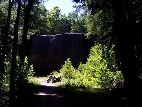 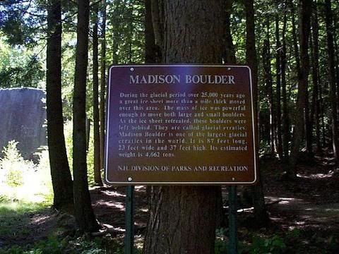 I'ld like that here, but the Bob Cat won't budge it....
__________________
06 1600 Nomad Just call me Mac molon labe come and get it |
|
|
|
11-25-2009, 11:57 PM
|
#37 |
|
Sr. Contributor
Join Date: Apr 2008
Location: Tamworth New Hampster 06 1600
Posts: 12,484
|
Satellite Photo Mystery?
On out USA tour we stopped at Devils Tower, and that is another form of volcano, with the basalt left standing, the rest erroded away.
I don't know it as fact, but I think it was parked over yellowstone once... The hot spots tend to stay put and the land mass moves away. We went to Ashfall Nebraska where rinos, three toe camels, and other creatures died in toxic airs, silty with silica glass dust, from a volcano said to have blown up in Idaho. The location is now at the top of a ridge line, but at the time was in a swamp down low. If I recall that date was 11 million years ago. Iddly in West Point NB walking around a pond recalimed from a gravel pit, recalimed from a corn field, re-calimed from the elk river, I found a pice of live oak fossilized from the 11 million year old event. I had no idea what I had at first. As i spotted what to me looked like porkypine chew deer antler, and picked it up the other side was a golden color all streaky amber.. Locals told me it was 'lightning' mean that lightning hit and melted the sand. I didn't think so, but I couldn't ID what it was either. I asked at Ashfall when I was introduced to a real geologist. He said nice specimen and pointed me to a live oak stump they had, much bigger than my specimen. The good thing with mine is we were on the nomad and I really could take big soveniers.. In Ky I was given a piece of fosillized carbon plant, the plant coal comes from, but it was stolen with all the stuff at the same time my 01 Nomad was.. The guy that gave it to me was just an old geezer and he had a very large dinosaur foot cast in coal. What this was i think was a real T-Rex foot print made of coal. This could only happen if the T-Rex left a foot print and then carbon plants fell into it and filled it, and I swear they did. I am not sure where the continent of N America was then, but I doubt it was where it is today.
__________________
06 1600 Nomad Just call me Mac molon labe come and get it |
|
|
|
11-26-2009, 10:35 AM
|
#38 |
|
Member

Join Date: Jul 2007
Location: Lennox, SD
Posts: 181
|
Satellite Photo Mystery?
That was cool!
__________________
Ride Safe Mike "Kioti" Gregg Peripheral visionary, wanderer, vagabond, pilgrim, rambler, roamer, nomad VBA #00380 VROC #11078 Lennox, SD *AMERICA by GOD* 2016 Kawasaki Vaquero 2009 Victory Vision - gone 2006 Kawasaki Nomad - gone 2002 Kawasaki 1500 Classic - gone "A Bumble Bee is considerably faster than a Super H Farmall" 2009 Black Hills Rally 2018 Black Hills Rally 
|
|
|
|
11-26-2009, 09:47 PM
|
#39 | |
|
Sr. Member

Join Date: Jan 2008
Location: Greenville, NC
Posts: 2,729
|
Satellite Photo Mystery?
Quote:
__________________
 Amy "kawgirl" Neal Greenville, NC 2002 Nomad |
|
|
|
|
11-27-2009, 09:15 AM
|
#40 | ||
|
Sr. Member
Join Date: Jul 2008
Location: Pasco , Wa
Posts: 1,445
|
Satellite Photo Mystery?
Quote:
http://en.wikipedia.org/wiki/File:Barringer_Crater_panoramic.jpg Here is a pic of the ming compound at the bottom for reference as to how big this is. http://en.wikipedia.org/wiki/File:Barringer_Crater_bottom.jpg |
||
|
|
 |
|
|
 Similar Threads
|
||||
| Thread | Thread Starter | Forum | Replies | Last Post |
| Mystery Nomad Rider - No Longer A Mystery | AlabamaNomadRider | Vulcan Nomad/Vaquero/Voyager | 18 | 07-08-2010 10:03 AM |
| Satellite Photo -- Who knows?!!! | glwilson | Off-Topic | 11 | 11-25-2009 04:04 PM |
| Satellite Radio? | jamiep24 | Vulcan Nomad/Vaquero/Voyager | 16 | 11-06-2009 12:19 AM |
| Satellite Radio | Vulcan Nomad/Vaquero/Voyager | 35 | 04-15-2008 06:27 PM | |
| SATELLITE RADIO | dogdoc | Vulcan Nomad/Vaquero/Voyager | 8 | 11-14-2007 07:46 PM |


 Linear Mode
